
North India Weather Update: Severe Rain, Dust Storms, and Hailstorms Predicted for Haryana, UP, and MP
A major shift in weather patterns is unfolding across the plains as a new Western Disturbance alert goes into effect.
RJ Kesari News Desk: While daytime temperatures continue to soar, bringing intense humidity and blinding sunshine, dynamic local cloud formations are developing during the late afternoons. This atmospheric transition is set to trigger abrupt, severe weather activities across multiple states.
Here is the comprehensive regional breakdown according to the latest IMD rainfall report for Wednesday, June 10, 2026.
⛈️ High Alert: Regions Bracing for Rain, Dust Storms, and Hail
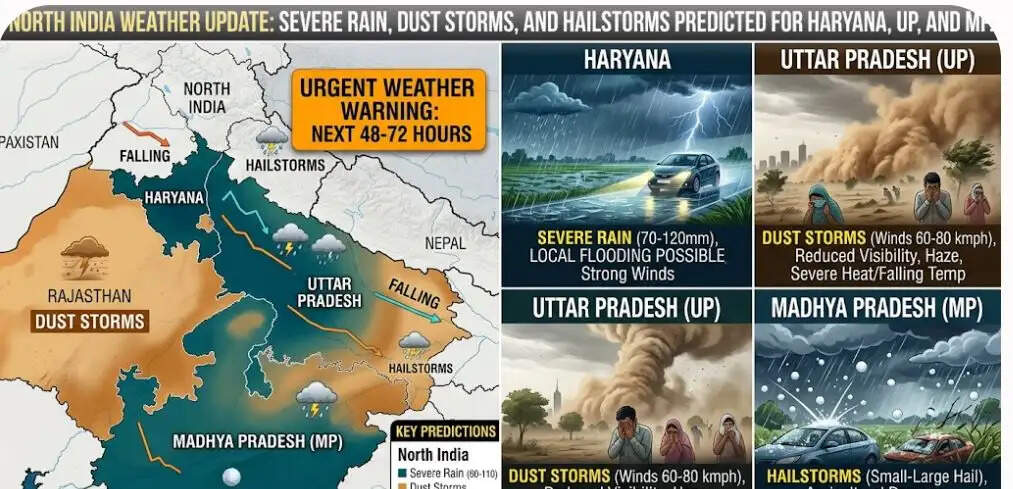
A turbulent combination of scattered light-to-moderate showers, powerful dust storms, and localized hailstorms is expected to impact the following regions:
-
Haryana: Southern districts are highly vulnerable to sudden evening storms.
-
Uttar Pradesh: Eastern and southern parts, along with the entire Bundelkhand belt.
-
Madhya Pradesh: Eastern zones, specifically across the Rewa, Sidhi, Satna, and Shahdol divisions.
-
Rajasthan: Northeastern pockets of the state.
💨 Expected Impact:
-
High-Speed Winds: Gale-force winds clocking speeds between 40 to 60 km/h are likely to sweep through these areas during the late afternoon and evening.
-
Sudden Cooling: Abrupt, heavy downpours will cause a rapid, temporary dip in local temperatures, bringing brief respite from the summer heat.
-
Key Urban Impact Zones: Cities like Varanasi, Mirzapur, Prayagraj, Sonbhadra, Chitrakoot, Banda, and Jhansi are advised to brace for rapidly deteriorating weather conditions.
☀️ Persistent Heatwave Conditions in Plains and Foothills
While some pockets get storm relief, a major portion of the northern plains will continue to suffer under extreme summer heat:
-
Dry and Scorching Zones: Punjab, Northern Haryana, Western Uttar Pradesh, Delhi-NCR, and Western/Southern Rajasthan will stay mostly clear and excessively hot.
-
Daytime Hazards: Temperatures will remain well above the seasonal average, maintaining intense heatwave conditions during peak afternoon hours. Only late evening might bring nominal relief via scattered cloud cover or isolated drizzles.
-
Hilly Terrains: The lower foothills of Jammu & Kashmir, Himachal Pradesh, and Uttarakhand will stay dry and warm over the next 24 hours. However, the mid-to-higher alpine reaches will experience isolated cloud development accompanied by light, scattered showers.
📅 Big Shift: Major Western Disturbance to Arrive on June 11
The overall regional climate is on the verge of a massive overhaul. Starting tomorrow, June 11, an intensifying Western Disturbance will draw significant moisture into the region.
This system is projected to expand the rain and hailstorm forecast across vast expanses of Northern and Central India. The upcoming phase will bring widespread moderate rainfall, frequent lightning strikes, intense squalls, and heavy hail, which is expected to break the prolonged cycle of the ongoing severe heatwave.